Tuesday, April 19, 2011
A Guide to Southern Santa Barbara County Surfing
View Guide to Southern Santa Barbara County Surfing in a larger map
Tuesday, April 12, 2011
Lab 2: Beverly Hills Topo Map Analysis
1. Beverly Hills Quadrangle
2. Canoga Park, Van Nuys, Burbank, Topanga, Hollywood, Venice, and Inglewood
3. 1966
4. North American Datum of 1927, 1983, and the National Geodetic Vertical Datum of 1929
5. 1:24,000
6.A. 5 cm. on the map is equal to 1200 m.
B. 5 in. on the map is equal to 1.894 mi.
C. 1 mi. is equal to 2.64 in. on the map
D. 3 km. is equal to 12.5 cm. on the map
7. 20 ft.
8.A. 34°4'23"N 118°26'15"W or N34.073° W118.437°
B. 34°0'30"N 118°30'0"W or N34.008° W118.50°
C. 34°7'17"N 118°24'37"W or N34.121° W118.410°
9.A. 580 ft. or 176.784 m.
B. 140 ft. or 42.672 m.
C. 700 ft. or 213.36 m.
10. UTM zone 11
11. 37,630,000 ft. N 3,610,000 ft. E
12. 1,000,000 sq. m. per UTM square
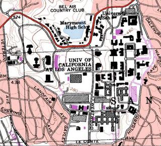
13.

14. 14° or 249 miles
15. The river flows South
16.
Tuesday, April 5, 2011
Three Enjoyable Maps


This topographical map shows a piece of Mount St. Helens. This map is from The United States Geographical Survey (USGS). This map contains many lines marking the contours and different heights of Mount St. Helens. There are labels, like "Lava Dome" and "Tallus Glacier," next to major physical structures on the mountain. The numbers on the map signify the maximum height at different locations along the rim of the crater. I find this map interesting because of the intricacy of the topographical lines.
Subscribe to:
Comments (Atom)