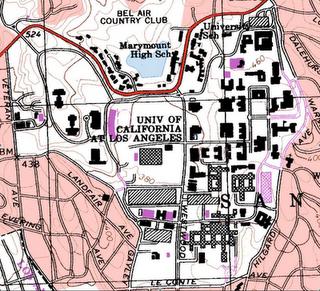
1. Beverly Hills Quadrangle
2. Canoga Park, Van Nuys, Burbank, Topanga, Hollywood, Venice, and Inglewood
3. 1966
4. North American Datum of 1927, 1983, and the National Geodetic Vertical Datum of 1929
5. 1:24,000
6.A. 5 cm. on the map is equal to 1200 m.
B. 5 in. on the map is equal to 1.894 mi.
C. 1 mi. is equal to 2.64 in. on the map
D. 3 km. is equal to 12.5 cm. on the map
7. 20 ft.
8.A. 34°4'23"N 118°26'15"W or N34.073° W118.437°
B. 34°0'30"N 118°30'0"W or N34.008° W118.50°
C. 34°7'17"N 118°24'37"W or N34.121° W118.410°
9.A. 580 ft. or 176.784 m.
B. 140 ft. or 42.672 m.
C. 700 ft. or 213.36 m.
10. UTM zone 11
11. 37,630,000 ft. N 3,610,000 ft. E
12. 1,000,000 sq. m. per UTM square
13.
15. The river flows South
16.


#9c -1
ReplyDelete32/33 = 9.7/10